Geodetic Control Point Establishment: A Comprehensive Guide
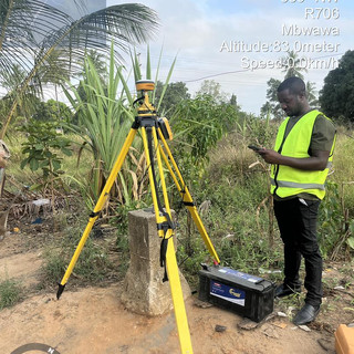
Establishing geodetic control points is a fundamental aspect of surveying and mapping that ensures accuracy and reliability in spatial data collection. Whether you are a seasoned surveyor or a novice in the field, understanding the process of establishing these control points is crucial for any project that requires precise geographical information. This guide will walk you through the steps, techniques, and best practices for establishing geodetic control points effectively.

Understanding Geodetic Control Points
What Are Geodetic Control Points?
Geodetic control points are fixed locations on the Earth's surface with known geographic coordinates. These points serve as reference markers for various surveying and mapping activities. They are essential for:
Mapping: Providing a framework for accurate mapping of land and features.
Surveying: Ensuring precise measurements in construction and land development.
Geospatial Analysis: Supporting various applications in GIS (Geographic Information Systems).
Importance of Geodetic Control Points
The establishment of geodetic control points is vital for several reasons:
Accuracy: They enhance the precision of measurements and data collection.
Consistency: Control points provide a consistent reference for different surveys over time.
Interoperability: They allow for the integration of data from various sources and technologies.
Steps to Establish Geodetic Control Points
Step 1: Planning and Preparation
Before establishing control points, thorough planning is essential. This includes:
Defining Objectives: Determine the purpose of the control points and the required accuracy.
Selecting Locations: Choose strategic locations that are accessible and stable. Avoid areas prone to movement or environmental changes.
Gathering Equipment: Ensure you have the necessary surveying equipment, such as GPS receivers, total stations, and leveling instruments.
Step 2: Conducting a Site Survey
Once you have your locations selected, conduct a preliminary site survey. This involves:
Assessing the Terrain: Evaluate the physical characteristics of the site, including elevation and vegetation.
Identifying Existing Control Points: Check for nearby established control points that can be used for reference.
Step 3: Establishing the Control Points
With your site survey complete, you can now establish the control points. This process typically involves:
Using GPS Technology: Utilize high-precision GPS equipment to measure the coordinates of the control point. This method is often preferred due to its accuracy and efficiency.
Marking the Points: Clearly mark the control points with durable markers, such as concrete monuments or metal rods, to ensure they are easily identifiable in the future.
Step 4: Data Collection and Verification
After establishing the control points, collect data to verify their accuracy. This includes:
Conducting Redundant Measurements: Take multiple measurements at different times to ensure consistency.
Comparing with Existing Data: Cross-reference your measurements with existing geodetic data to confirm accuracy.
Step 5: Documentation
Proper documentation is crucial for future reference and use. Ensure you:
Record Coordinates: Document the geographic coordinates of each control point.
Create a Site Plan: Develop a detailed site plan that includes the locations of all control points and any relevant features.
Best Practices for Geodetic Control Point Establishment
Choose the Right Equipment
Selecting the appropriate surveying equipment is critical for accuracy. High-quality GPS receivers and total stations can significantly improve measurement precision. Consider investing in equipment that meets the specific needs of your project.
Ensure Stability of Control Points
The stability of control points is paramount. Avoid locations that may be affected by erosion, construction, or natural disasters. Regularly check and maintain the markers to ensure they remain intact.
Collaborate with Local Authorities
Engaging with local surveying authorities can provide valuable insights and resources. They may have existing control points that can be integrated into your project, saving time and resources.
Stay Updated with Technology
The field of geodesy is continually evolving with advancements in technology. Stay informed about new tools and techniques that can enhance the establishment and maintenance of control points.
Challenges in Establishing Geodetic Control Points
Environmental Factors
Environmental conditions can significantly impact the accuracy of measurements. Factors such as weather, vegetation, and terrain can introduce errors. It is essential to account for these variables during the planning and measurement phases.
Human Error
Human error is another common challenge in establishing control points. Ensure that all personnel involved in the process are well-trained and follow established protocols to minimize mistakes.
Technological Limitations
While technology has advanced significantly, limitations still exist. GPS accuracy can be affected by satellite visibility and atmospheric conditions. Always have backup methods for verification.
Conclusion
Establishing geodetic control points is a critical process that requires careful planning, execution, and maintenance. By following the steps outlined in this guide and adhering to best practices, you can ensure the accuracy and reliability of your geospatial data. Remember, the precision of your measurements can significantly impact the success of your projects, making the establishment of control points a fundamental aspect of surveying and mapping.
As you embark on your journey to establish geodetic control points, consider the importance of continuous learning and adaptation to new technologies. The field of geodesy is dynamic, and staying informed will enhance your skills and the quality of your work.


Comments