Topographic Surveys: Essential for Construction Projects
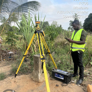
In the world of construction, the foundation of any successful project lies in accurate planning and assessment. One crucial aspect that often gets overlooked is the topographic survey. This survey provides detailed information about the land's surface, including its contours, elevations, and features. Understanding the importance of topographic surveys can significantly impact the success of construction projects, ensuring they are completed on time, within budget, and to the desired specifications.
What is a Topographic Survey?
A topographic survey is a detailed representation of the three-dimensional features of a piece of land. It includes the location of natural and man-made features such as:
Elevation changes: Hills, valleys, and slopes
Water bodies: Rivers, lakes, and ponds
Vegetation: Trees, shrubs, and other plant life
Structures: Buildings, roads, and fences
These surveys are typically conducted by licensed surveyors using advanced technology such as GPS, total stations, and drones. The resulting maps and data are essential for architects, engineers, and construction managers to make informed decisions.
Why Are Topographic Surveys Important?
Topographic surveys play a vital role in various stages of construction projects. Here are some key reasons why they are essential:
1. Accurate Site Analysis
Before any construction begins, it is crucial to understand the site conditions. A topographic survey provides a clear picture of the land, allowing project teams to analyze factors such as drainage patterns, soil stability, and potential obstacles. This information helps in designing structures that are safe and suitable for the environment.
2. Improved Design and Planning
With accurate topographic data, architects and engineers can create designs that fit the land's natural features. This leads to more efficient use of space and resources. For example, if a survey reveals a steep slope, the design can incorporate retaining walls or terraces to manage the elevation change effectively.
3. Cost Savings
Investing in a topographic survey can save money in the long run. By identifying potential issues early in the planning process, teams can avoid costly changes during construction. For instance, if a survey uncovers underground utilities or unstable soil, adjustments can be made before breaking ground, preventing delays and additional expenses.
4. Regulatory Compliance
Many local governments require topographic surveys for permitting and zoning approvals. These surveys ensure that construction projects comply with regulations regarding land use, environmental impact, and safety standards. Failing to provide accurate topographic data can lead to project delays or even legal issues.
5. Enhanced Communication
Topographic surveys provide a common reference point for all stakeholders involved in a construction project. This includes architects, engineers, contractors, and clients. Having a clear visual representation of the site helps facilitate discussions and decision-making, reducing misunderstandings and ensuring everyone is on the same page.
The Process of Conducting a Topographic Survey
Conducting a topographic survey involves several steps, each crucial for obtaining accurate data. Here’s a breakdown of the process:
Step 1: Pre-Survey Planning
Before the survey begins, surveyors conduct a site visit to assess the area and determine the best approach. This includes identifying key features to be mapped and planning the survey's scope.
Step 2: Data Collection
Using advanced equipment, surveyors collect data on the land's features. This may involve:
GPS technology: For precise location data
Total stations: For measuring angles and distances
Drones: For aerial surveys of large or difficult-to-access areas
Step 3: Data Processing
Once the data is collected, it is processed using specialized software to create detailed topographic maps. These maps illustrate the land's contours, elevations, and features in a clear and understandable format.
Step 4: Reporting
The final step involves compiling the survey results into a comprehensive report. This report includes maps, data analysis, and recommendations for the project team. It serves as a valuable resource throughout the construction process.

Applications of Topographic Surveys in Construction
Topographic surveys are used in various construction projects, from residential developments to large infrastructure projects. Here are some specific applications:
Residential Construction
For residential projects, topographic surveys help homeowners and builders understand the land's characteristics. This information is crucial for:
Designing homes that fit the landscape
Planning drainage systems to prevent flooding
Ensuring compliance with local building codes
Commercial Development
In commercial projects, topographic surveys assist in site selection and design. Developers can assess the suitability of a location for retail, office, or industrial use. Key considerations include:
Accessibility and visibility
Environmental impact
Zoning regulations
Infrastructure Projects
For large infrastructure projects such as roads, bridges, and utilities, topographic surveys are indispensable. They provide essential data for:
Route planning and alignment
Identifying potential hazards
Estimating construction costs and timelines
Environmental Assessments
Topographic surveys are also used in environmental assessments to evaluate the impact of construction on natural resources. This includes:
Identifying wetlands and floodplains
Assessing wildlife habitats
Planning for erosion control and conservation efforts
Challenges in Topographic Surveys
While topographic surveys are essential, they are not without challenges. Some common issues include:
1. Weather Conditions
Adverse weather can hinder data collection efforts. Rain, snow, or high winds can affect the accuracy of measurements and the safety of survey crews.
2. Accessibility
Some sites may be difficult to access due to rough terrain, dense vegetation, or urban development. Surveyors must find creative solutions to gather data in these challenging environments.
3. Technological Limitations
While modern technology has improved the accuracy and efficiency of topographic surveys, it is not infallible. Equipment malfunctions or human error can lead to inaccuracies in the data collected.
4. Regulatory Changes
Changes in local regulations can impact the requirements for topographic surveys. Surveyors must stay informed about these changes to ensure compliance and avoid delays in project approvals.
Future Trends in Topographic Surveys
As technology continues to evolve, the field of topographic surveying is also changing. Here are some trends to watch for in the future:
1. Increased Use of Drones
Drones are becoming more common in topographic surveys due to their ability to cover large areas quickly and safely. They provide high-resolution aerial imagery that can enhance the accuracy of surveys.
2. Integration of GIS Technology
Geographic Information Systems (GIS) are increasingly being integrated into topographic surveys. This technology allows for better data analysis and visualization, making it easier to understand complex site conditions.
3. Real-Time Data Collection
Advancements in technology are enabling real-time data collection during surveys. This allows for immediate analysis and decision-making, improving project efficiency.
4. Sustainable Practices
As environmental concerns grow, there is a push for more sustainable surveying practices. This includes minimizing the impact of surveys on natural habitats and using eco-friendly equipment.
Conclusion
Topographic surveys are a fundamental component of successful construction projects. They provide essential data that informs design, planning, and execution, ultimately leading to safer and more efficient builds. By understanding the importance of these surveys, construction professionals can enhance their project outcomes and ensure compliance with regulations. As technology continues to advance, the future of topographic surveying looks promising, offering even more tools and techniques to support the construction industry.
Investing in a topographic survey is not just a good practice; it is a necessary step for anyone looking to embark on a construction project. Whether you are a homeowner, developer, or contractor, understanding the land you are working with will lead to better decisions and successful outcomes.


Comments