top of page
LAND INVESTMENT IN TANZANIA
Hellow...!! Fellow Surveyors, Business men and Investors, Investing in land needs smartness and strategic move. Today we are going to scratch through 3 Reasons Why People Should Invest in Land. 1. Land Doesn’t Depreciate Unlike cars or gadgets, land doesn’t lose value—it appreciates over time. The more development around it, the more valuable it becomes. Buying land today means securing tomorrow’s wealth. 2. It’s a Tangible Asset You Can Trust Land is real. You can see it, to
yusuph rashid
Aug 184 min read


Boundary Verification Services Explained: What You Need
Boundary verification is a crucial aspect of property ownership and development. Whether you are a homeowner, a real estate investor, or a developer, understanding the boundaries of your property can save you from legal disputes and financial losses. In this blog post, we will explore what boundary verification services entail, why they are important, and how you can benefit from them. What Are Boundary Verification Services? Boundary verification services involve the process
yusuph rashid
Aug 165 min read


Topographic Surveys: Essential for Construction Projects
In the world of construction, the foundation of any successful project lies in accurate planning and assessment. One crucial aspect that often gets overlooked is the topographic survey. This survey provides detailed information about the land's surface, including its contours, elevations, and features. Understanding the importance of topographic surveys can significantly impact the success of construction projects, ensuring they are completed on time, within budget, and to th
yusuph rashid
Aug 165 min read


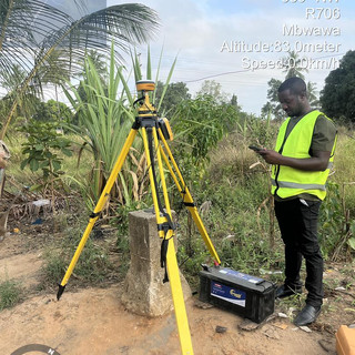
Geodetic Control Point Establishment: A Comprehensive Guide
Establishing geodetic control points is a fundamental aspect of surveying and mapping that ensures accuracy and reliability in spatial data collection. Whether you are a seasoned surveyor or a novice in the field, understanding the process of establishing these control points is crucial for any project that requires precise geographical information. This guide will walk you through the steps, techniques, and best practices for establishing geodetic control points effectively.
yusuph rashid
Aug 163 min read
bottom of page